SOURCE: IDRW.ORG TEAM
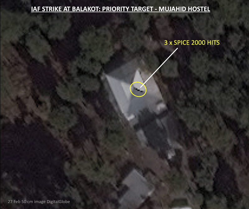
In a significant revelation, Air Chief Marshal B.S. Dhanoa (Retd.), former head of the Indian Air Force (IAF), has confirmed the possession of classified Synthetic Aperture Radar (SAR) imagery that supports India’s success in striking Jaish-e-Mohammed terror training camps deep inside Pakistan following the Balakot airstrikes. These images, according to Dhanoa, counter the initial assessments made by international agencies relying on open-source imagery.
Speaking to livefistdefence.com, Dhanoa emphasized the importance of high-resolution images for accurate damage assessment. “To see an 80cm hole in a building, you need to put at least 2 pixels on the hole (approximately 40cm resolution),” he explained. International agencies, lacking knowledge of the specific aim points and advanced weaponry deployed by the IAF, had initially underestimated the impact of the strikes.
Further, Dhanoa addressed claims that India relied on inaccurate Shuttle Radar Topography Mission (SRTM) data, which suggested an elevation error in targeting. He dismissed the idea, stating, “Nothing could be more naïve to think that we are in possession of weapons that are capable of being programmed with Level 2 Digital Terrain Elevation Data (DTED) and we don’t have our own Digital Elevation Model (DEM)!”
Air Chief Marshal Dhanoa’s statements provide crucial insights into the technological capabilities of the IAF and the precision achieved in the Balakot airstrikes. They bolster India’s claims of successfully targeting terrorist infrastructure within Pakistan and underscore the challenges of relying solely on open-source information for assessing the outcomes of such operations.
NOTE : Article cannot be reproduced without written permission of idrw.org in any form even for YouTube Videos to avoid Copy right strikes. Websites doing illegal reproductions will get DMCA and Legal Notices.