SOURCE: ISRO
Cartosat-2, ISRO’s first satellite in the second generation of high-resolution imaging satellites, launched on January 10, 2007. It weighed 680 kg at launch and operated in a sun-synchronous polar orbit at an altitude of 635 km. Until 2019, it provided high-resolution imagery for urban planning.
Initially, Cartosat-2 was expected to take about 30 years to naturally de-orbit. However, ISRO opted to lower its perigee using leftover fuel to comply with international guidelines on space debris mitigation. This involved reducing collision risks and ensuring safe end-of-life disposal, following recommendations from organizations like the United Nations Committee on the Peaceful Uses of Outer Space (UN-COPOUS) and the Inter-Agency Space Debris Coordination Committee (IADC).
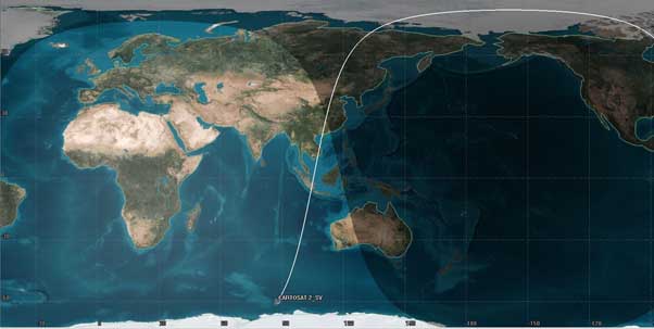
ISRO’s System for Safe and Sustainable Space Operations (IS4OM) team at ISRO Telemetry Tracking and Command Network (ISTRAC) predicted Cartosat-2’s atmospheric re-entry for February 14, 2024. Electrical passivation was completed on February 14th, and tracking continued until re-entry. The final telemetry frames confirmed successful passivation, with the satellite reaching about 130 km altitude.

This provided an opportunity to assess indigenous tracking capabilities, with the Multi-object tracking radar at Shriharikota utilized for tracking. The final prediction placed Cartosat-2’s re-entry over the Indian Ocean at 10:18 UTC / 3:48 pm IST on February 14, 2024. Analysis indicated that all major spacecraft components would demise during atmospheric re-entry.
Cartosat-2’s successful de-orbiting at its end-of-life represents a significant step for ISRO in ensuring the long-term sustainability of outer space activities.