SOURCE: AFI
In recent geopolitical developments, Nepal has released a new political map that has stirred significant controversy and debate. The map, which incorporates territories long-disputed with India, marks a significant shift in Nepal’s cartographic representations and has drawn criticism and concern from its southern neighbor. This move is unprecedented, as the areas claimed by Nepal have not been depicted in its maps for over 170 years, according to a new book.
The roots of this territorial dispute trace back to the early 19th century. The Sugauli Treaty of 1815-16, signed between the British East India Company and the Kingdom of Nepal, delineated the boundary lines that have been the source of contention. The treaty, which followed the Anglo-Nepalese War, effectively reduced Nepal’s territory and established the Mahakali River as the western boundary. However, differing interpretations of the river’s source have led to ongoing disputes.
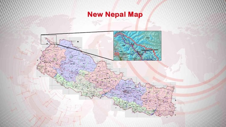
The new map released by Nepal includes three key areas: Kalapani, Lipulekh, and Limpiyadhura. These regions, situated at the strategic trijunction of India, China, and Nepal, have significant strategic and economic importance. Historically, these areas have been administered by India, and Indian maps have consistently depicted them as part of Indian territory.
- Kalapani: This area has been under Indian administration since the 1962 Sino-Indian War, where Indian military outposts were established to monitor Chinese movements.
- Lipulekh: This pass is strategically important as it serves as a trade and pilgrimage route, linking India with Tibet.
- Limpiyadhura: The inclusion of this region is based on Nepal’s interpretation of historical documents, asserting that the river source lies here, thereby extending Nepal’s territory further west than currently recognized by India.
Nepal’s release of the new map has escalated tensions between Kathmandu and New Delhi. India has categorically rejected the map, terming it as an “artificial enlargement” of Nepalese territory that is not based on historical facts or evidence. India’s Ministry of External Affairs has expressed concern that such unilateral actions will complicate the boundary discussions.
Conversely, Nepal defends its stance by citing historical documents and treaties. The Nepalese government has maintained that their claims are legitimate and rooted in historical accuracy. The move has been seen by some analysts as a way for Nepal to assert its sovereignty and territorial integrity amidst growing regional influences and pressures.
The publication of the book highlighting the historical context of Nepal’s map claims has added a scholarly dimension to the debate. The book argues that the areas in question have not been depicted in Nepal’s maps for over 170 years, suggesting a significant deviation from historical cartographic records. This raises questions about the motivations and timing behind Nepal’s new claims.
The academic community remains divided on the issue. Some historians support Nepal’s claims, arguing that colonial-era treaties were often coercive and skewed in favor of the British Empire and its allies. Others caution that redrawing boundaries based on historical interpretations can lead to geopolitical instability and conflict.
The controversy over Nepal’s new map is emblematic of the broader geopolitical dynamics in South Asia. The region has seen increasing nationalistic fervor, with countries asserting territorial claims more aggressively. This trend, coupled with China’s rising influence and the strategic importance of the Himalayan region, adds layers of complexity to the dispute.
Furthermore, the map issue touches on themes of national identity and historical rectification. For Nepal, asserting these territorial claims is not merely a geopolitical maneuver but also an affirmation of its national sovereignty and historical narrative.
The release of Nepal’s new map has opened a complex and sensitive chapter in South Asian geopolitics. While historical treaties and interpretations play a crucial role in such disputes, the path forward lies in diplomatic dialogue and negotiation. Both Nepal and India need to engage in constructive discussions to address their differences, keeping in mind the broader implications for regional stability and cooperation.