SOURCE: AFI
ideaForge Technology Limited, a global leader in drone technology, announced a strategic partnership with Inertial Labs, a pioneer in innovative inertial sensors and integrated GPS systems. This collaboration aims to integrate Inertial Labs’ cutting-edge RESEPI LiDAR solution into ideaForge’s high-performance UAVs, delivering enhanced accuracy and reliability for aerial data collection and 3D mapping.
The partnership addresses the growing demand for LiDAR-based drones across industries such as surveying, mapping, mining, construction, forestry, power line inspection, and search and rescue. By combining ideaForge’s UAV expertise with Inertial Labs’ precise LiDAR technology, the collaboration offers a powerful solution for capturing aerial data with unmatched precision and speed.
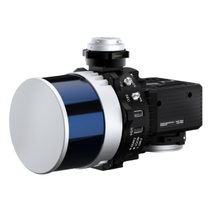
The integration of Inertial Labs’ RESEPI LiDAR payload with ideaForge’s NETRA/Q6 class of UAVs enables efficient data collection for various applications, including mining assessments, long-range surveying, and utility infrastructure management. The high point cloud density and accuracy provided by the system capture even the minutest details, delivering actionable insights for informed decision-making.
“Our partnership with Inertial Labs marks a significant milestone in advancing UAV-based LiDAR mapping capabilities,” said Ezhilan Nanmaran, Head of Product and Strategic Partnerships at ideaForge Technology Limited. “This collaboration empowers us to deliver unparalleled precision and efficiency in data collection, revolutionizing mapping practices across diverse sectors.”
Jamie Marraccini, CEO at Inertial Labs, expressed enthusiasm about the partnership, emphasizing the commitment to industry advancement. The collaboration combines both companies’ innovative technologies to deliver top-tier accuracy and reliability, empowering users across various sectors.
Key Specifications of ideaForge’s NETRA/Q6 Class UAV:
- One-man portable
- MTOW <6kg
- Multi-use platform
- 27X Zoom, Thermal, Mapping, Multispectral, LiDAR
- GCS software with fully autonomous flying and built-in fail-safes
- Custom maps and terrain-following for accurate resolution in hilly areas/mines
This strategic partnership between ideaForge and Inertial Labs is poised to redefine the UAV-based LiDAR mapping industry, offering customers a comprehensive and reliable solution for their data collection needs.